How App Companies Can Build Trust with Customers
Learn how app companies can build customer trust through better privacy practices, transparent communication, and stronger security to improve retention and...
Updated December 18, 2024

Businesses can use an indoor positioning and navigation app to map out large buildings, like malls and airports, for visitors. This article explains how those apps work, as well as how much effort it takes to create one.
Shopping malls, offices, university campuses, hospitals, airports, warehouses – all these buildings take up a large area, challenging visitors who want to find their way quickly.
Indoor positioning and navigation apps can solve that problem.
Looking for a Mobile App Development agency?
Compare our list of top Mobile App Development companies near you
The idea behind indoor positioning and navigation apps is simple: Inside large facilities – where GPS does not work — the app helps smartphone users locate and get to certain destinations.
My team at IT Craft has been helping to create navigation platforms capable of providing benefits for both facility owners and visitors. These platforms can be quickly adjusted based on each facility’s requirements. We wanted to share some of our expertise with you, including how indoor positioning apps function and how to make them.
An indoor navigation app shows visitors their position on the map and creates the shortest route to a destination. It also lets users receive messages from system administrators.
An example is Gatwick Airport's app, which directs users to their destinations.
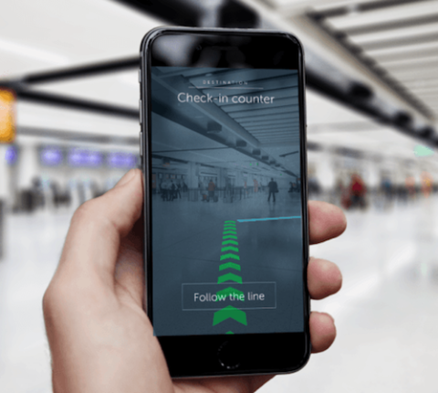
The app uses augmented reality (AR) technology and beacons to create comprehensive indoor maps.
Indoor navigation apps have three main purposes: positioning, navigation, and push notifications.
For visitors, the app makes it possible to use their smartphones to get to their chosen destination. This includes but is not limited to:
For facility and business owners, the app makes it possible to:
Indoor navigation apps combine data from several sources to calculate a user’s position.
The input data includes:
Thus, an indoor navigation system needs:
An indoor navigation system also needs hardware, and there are three main types.
The best way to ensure accuracy is to mix these approaches.
Wi-Fi access points function as signal transmitters. They do not calculate user position – the user’s smartphone does that, which eats up battery life.
BLE Beacons have a long battery life and a 2- to 3-meter range accuracy. Both Android and iOS devices support their signals.
Also, BLE beacons-based navigation solutions calculate the route on the server, eliminating extra load on the user device.
However, a user must be within the range of at least three BLE beacons. This is called the triangulation method.

The number of beacons required depends on the number of obstacles, such as walls. The Indoor Beacon Calculator helps determine how many beacons you need.
Geofencing uses a smartphone’s built-in compass and a geomagnetic map of the venue.
However, the magnetic field must be stable. With every new source of electromagnetic emission, the product owner has to update the geomagnetic map.
An indoor navigation should have the following basic features:
You might also want to include some optional features, such as:
Basic features cost between $10,000 to 50,000. Optional features range from $20,000 to $50,000.
When it comes to hardware, the average price for a three-piece kit of BLE Beacons is $20 to $60 each. The price for geofencing differs based on your request.
After you make or commission an indoor navigation app, expect to update it routinely. Some of the services you might have to pay for after development include:
You’ll have to pay for a subscription to a location engine and possibly PaaS (Platform-as-a-Service) solutions, such as map storage, to cut down on maintenance.
Product owners should create a server with all the mapping information stored. This saves time when a beacon’s battery dies and you need a replacement. Another server contains information on marketing campaigns and BLE beacons used for push notifications.
Indoor navigation apps should be updated every time beacons or smartphones are updated. That way, your app won't experience glitches.
An indoor positioning and navigation app helps visitors find their way inside large facilities. For businesses, the app provides analytics tools to study user behavior.
An indoor navigation system can use different technologies – based on which technology is the best fit for the provided type of facility. It switches seamlessly from one technology to another, as required.
If you’re searching for a method to help people find their way inside large complexes, such as airports and malls, an indoor navigation app may be the solution.
 Anthony Suddia is a content specialist at web and mobile development company IT Craft. He enjoys writing about IT Craft’s experience in technical and managerial questions related to custom software development. Anthony focuses on trends in digital technologies that make people’s lives more comfortable.